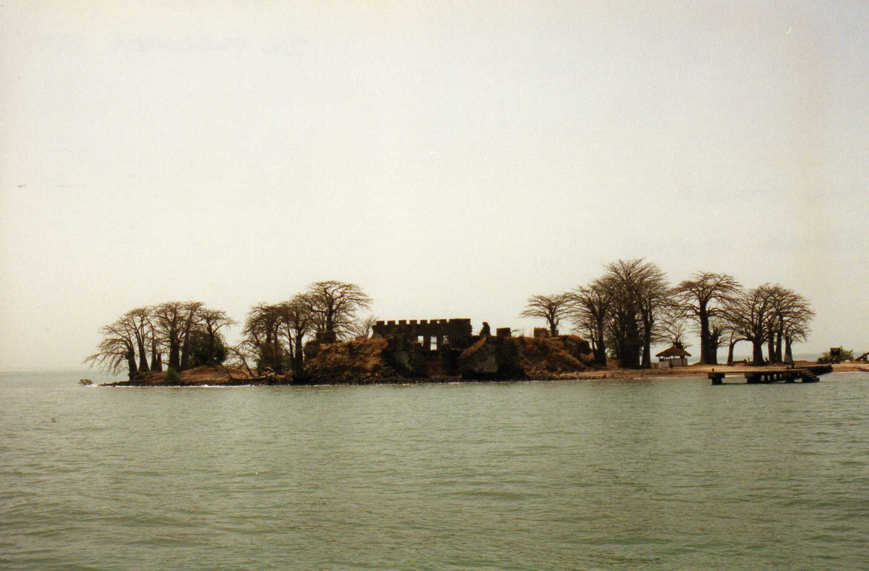
What it is
A small island in the River Gambia with the ruins of a fort first built in 1651 and held by several European powers over the next two centuries.[1] UNESCO listed it in 2003 together with six related sites, for what they show about contact between Africa and Europe from the 15th century onward, including both the growth and the abolition of the slave trade.[2]
- Inscribed
- 2003[2]
- Criteria
- iii and vi[2]
- Component sites
- 7[2]
- Core area
- 7.6 ha, 300 ha buffer[2]
- Spread along river
- about 30 km[3]
- James Island area
- 0.3 ha[4]
- Island today
- about one sixth of its original size[1]
The seven sites are the island and its fort, the Portuguese chapel ruins and the CFAO colonial warehouse in Albreda, the Maurel Frères building in Juffureh, the San Domingo Portuguese settlement remains, Fort Bullen, and the Six-Gun Battery.[2]
The evaluation that ICOMOS wrote for the inscription adds detail. James Island is tiny, 0.3 ha. Its fort is roughly square with a polygonal bastion at each corner, and every historic structure on it is a ruin that the waves reach at high tide and in storms.[4] The Maurel Frères building was put up around 1840 by the British and later used as a warehouse by a trader called Maurel. It became a small museum on the Atlantic slave trade in 1996. The Six-Gun Battery, with six 24-pounder guns, stands in Banjul, and Fort Bullen at Barra Point faces it across the river mouth.[4]
ICOMOS names James Island, together with Gorée in Senegal, as one of the two main places in the region from which enslaved people were shipped to Europe and America. It also states that no accurate figures exist for how many people were taken from James Island, and calls it one of the most important places of memory for the African diaspora.[4]
Timeline
- 1651A company of the Duke of Courland, which obtained the island from its hereditary rulers, the Niuminkas, starts building the first fort. The encyclopedia article names it Jacob Fort and says it was built under Major Fock.[4][1]
- 1659–1664The Dutch take the fort in 1659. Local African kingdoms side with the Courlanders and the Dutch withdraw. The English capture the island in 1661 and the Dutch formally cede it in 1664. It becomes James Island, with Fort James, named for the Duke of York.[1]
- 1695–1702The French seize Fort James in 1695 and have lost it again by 1702.[1]
- 1750The Company of Merchants Trading to Africa takes over administration, after earlier English companies that traded in gold, ivory and enslaved people.[1]
- 1807The British Abolition Act makes the slave trade illegal in the British Empire. Two defensive works follow on the river, built to stop it.[4][1]
- By 1815The fort on James Island is abandoned. ICOMOS says it had been destroyed and rebuilt several times as it passed between the British, French, Dutch, pirates and mutineers, last destroyed at the end of the 18th century, and has stayed in ruins since.[4]
- 1816, 1826The Six-Gun Battery (1816) and Fort Bullen (1826) are built at the river mouth to thwart the slave trade. ICOMOS also says the battery was completed in 1821, and calls the pairing of the island and these two works unique in West Africa.[4][1]
- 1870Fort Bullen and the Six-Gun Battery are abandoned. Fort Bullen is reused for a time in the Second World War as an observatory and artillery base.[4]
- 2003UNESCO inscribes the property, then named James Island and Related Sites. The State Party had put forward criteria (iv) and (vi). ICOMOS recommended (iii) and (vi), and those are the ones listed.[2][4]
- 6 Feb 2011The island is renamed Kunta Kinteh Island at the request of the artist Chaz Guest.[1]
- 23 Aug 2016Heavy rain and wind in Albreda and Juffureh strip part of the roof from the CFAO building. Gambian authorities ask UNESCO for international assistance.[3]
- Mar 2020A National Assembly committee visits the island and calls for urgent action against sea erosion. The press report lists no completed measures.[5]
The entries for 1651 to 1750 and for 2011 come in part or wholly from an encyclopedia article. They are marked for checking against book-length sources.
The name and the novel
The island carries the name of Kunta Kinte, the ancestor in Alex Haley's Roots. Haley called the book "faction": a mix of documented history and invented scenes.[6] The ICOMOS evaluation notes that Juffureh is now a pilgrimage destination because Haley identified it as the village of his ancestors.[4]
Historians have disputed its genealogy. Gary and Elizabeth Mills found that the plantation records they examined contradict Haley's account of the American side of the family.[6] On the Gambian side, the head of the national archives doubted the reliability of the griot whose account Haley relied on. The historian Donald Wright wrote in 1981 that Haley's repeated visits led some local people to take in his version, which was then repeated back to him.[6] Donald Wright's 1981 article, titled "Uprooting Kunta Kinte: On the Perils of Relying on Encyclopedic Informants", questions the basis of Haley's genealogy. Its abstract says Haley claimed to have proved his ancestor's existence largely through oral history.[7] Juffureh also lies about two miles from James Island, a British post since 1661, which sits uneasily with the novel's picture of a village cut off from Europeans.[6]
Jean Muteba Rahier's unfinished study of heritage tourism in Juffureh reports that local guides trained by tourism officials present the story as history, and that many officials, journalists, visitors and guides treat the novel as if it were documented fact.[8]
None of this settles what the island meant in the trade itself. It does mean this card keeps the novel's story and the documented history apart.
- How many people were embarked through this site, and in which years. ICOMOS says that no accurate figures exist. No dataset or historian's account of voyages has been retrieved for this card.
- Primary sources behind the timeline, such as company records and travellers' accounts.
- The condition of the island and the other six sites today. ICOMOS describes it as of 2003, and the newest source found is from 2020.
- The full text of Wright's 1981 article. Only its abstract was read, so the card does not repeat what Wikipedia says the article found.
- What the island means in daily life for people in Juffureh and Albreda. Only the local voices on this card can answer that.
Sources
- Encyclopedia · to verify[1] Kunta Kinteh Island. Wikipedia. en.wikipedia.org retrieved 6 Oct 2026
Most dates in the timeline come from here. Replace or confirm with book-length sources. - Institutional[2] Kunta Kinteh Island and Related Sites. UNESCO World Heritage Centre. whc.unesco.org retrieved 6 Oct 2026
- Institutional[3] News item on storm damage at the site, August 2016. UNESCO World Heritage Centre. whc.unesco.org retrieved 6 Oct 2026
- Institutional[4] James Island and Related Sites (Gambia), No 761 rev: evaluation by the Advisory Body. ICOMOS, for the UNESCO World Heritage Committee. whc.unesco.org retrieved 6 Oct 2026
Technical evaluation written for the 2003 inscription, under the property's earlier name. It reports both the State Party's own justification and ICOMOS's view; the card uses the ICOMOS parts unless it says otherwise. - Press[5] Sea erosion threatens Kunta Kinteh Island. The Point (Banjul), 11 Mar 2020. thepoint.gm retrieved 6 Oct 2026
- Encyclopedia · to verify[6] Roots: The Saga of an American Family, section on factual accuracy. Wikipedia. en.wikipedia.org retrieved 6 Oct 2026
Summarises the work of Mills and Mills, Donald Wright and others. Go to those originals. - Academic · to verify[7] Donald R. Wright, Uprooting Kunta Kinte: On the Perils of Relying on Encyclopedic Informants. History in Africa, vol. 8 (1981), pp. 205-217. www.cambridge.org retrieved 6 Oct 2026
Only the abstract was read. The full article is behind a paywall. - Academic · draft[8] Jean Muteba Rahier, Roots/Heritage Tourism in Juffureh. Florida International University. africana.fiu.edu retrieved 6 Oct 2026
Work in progress, no publication year shown.